

Photo Red Trillium by Brian Prose
Rock Run
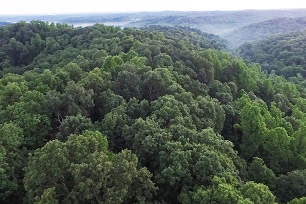
Rock Run Wilderness. Rock Run is an 802-acre Arc Preserve region protecting the Appalachian hill country surrounding the exceptionally deep ravine of Rock Run, a small but pristine creek that flows directly out of Shawnee Forest and into the Ohio River. Surrounded by the 60,000 + acre Shawnee State Forest and privately-owned forests, Rock Run belongs to one of the largest near-contiguous blocks of forest left in the state, one that is over 100 square miles in size. This region is one of the most important refuge for biodiversity in the entire state – sheltering bobcat, timber rattlesnakes, and scores of rare and endangered plants.
Hiking: Sunrise to Sunset
Address: U.S. Rt 52, Stout, OH 45684
A note on ticks & chiggers
Download and Go! - Hiking Guide and More Information
A dog owner's guide to hiking the Arc of Appalachia

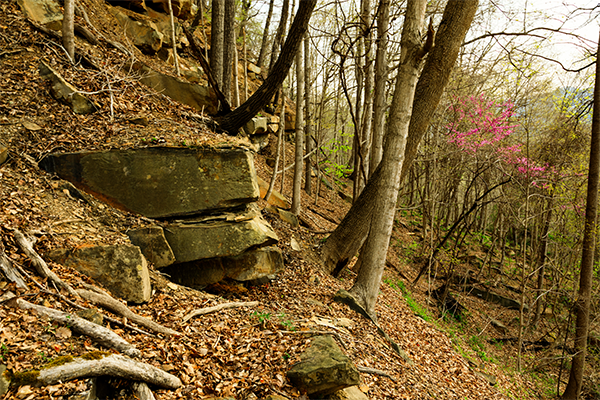
Sandstone Rock Outcrop - Brian Prose
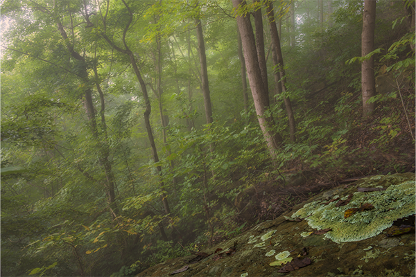
Rock Run's Mist-filled Forest. Photo by Tom Croce Photography | tomcrocephoto.com
Rock Run's sublime wilderness. Photo by Dave Ackerman.
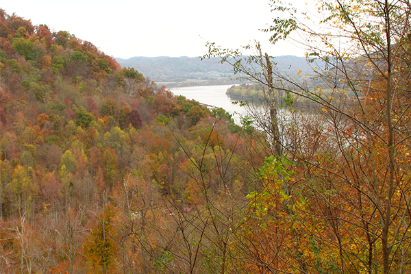
View overlooking the Ohio River. Photo by Jon Srofe.
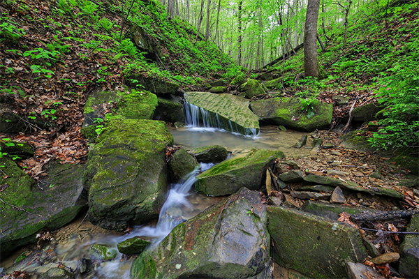
Rock Run Waterway. Photo by Brian Prose.
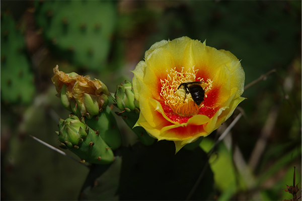
Prickly Pear Cactus at Sandy Springs. Photo by John Howard.
Rock Run Wilderness. Rock Run is an 802-acre preserve that protects the Appalachian hill country surrounding the exceptionally deep ravine of Rock Run, a small but pristine creek that flows directly out of Shawnee Forest and into the Ohio River. Surrounded by the 60,000+ acre Shawnee State Forest and privately-owned forests, Rock Run belongs to one of the largest near-contiguous blocks of forest left in the state at more than 100 square miles in size. This region is one of the most important refuges for biodiversity in Ohio – sheltering bobcats, timber rattlesnakes, and scores of rare and endangered plants.
Rock Run Watershed is pristine and biologically-rich. Rock Run ranks among the top 5% of all Ohio streams in its size class - possessing outstanding water quality and biological integrity. When the Arc became active in the region in 2004, half of the watershed of Rock Run was owned and managed by Shawnee State Forest. The Arc’s long held goal was to slowly purchase the remaining half of Rock Run’s watershed, parcel by parcel, until the entire watershed was under conservation protection. To accomplish such a feat anywhere in Ohio would be a rare and extraordinary event–and it was! But the relatively small size of Rock Run’s drainage and its location in the heart of Shawnee State Forest made it a more likely candidate than most. The Arc of Appalachia made its first purchase for Rock Run Preserve in 2004. Ten Arc acquisitions later, our dream of full watershed protection has been realized!
Rock Run’s Appalachian Hardwood Forest: Oaks and hickories grow in the upper slopes at Rock Run, while sugar maple, red maple, black birch, hemlock, beech, and tulip poplars are most often found in the mid and lower elevations. Scattered in the deepest ravines of Rock Run are also black birch-hemlock communities, a forest type that is quite rare in Ohio, but was once relatively common in the coves of the Appalachian mountains to our east.
Rock Run’s trees were timbered several times since the inception of Ohio statehood for the purpose of producing sawlogs and charcoal. The last harvest took place in the late 1990s. The preserve’s woodlands are now being permitted to return to full and uninterrupted maturity. Because the steepest slopes hindered tree harvesting, visitors will already see trees of impressive girth growing on the hillsides.
Rock Run provides critical breeding and nesting habitat for several deep forest bird species, including cerulean, worm-eating, and hooded warblers. All of these Eastern species of warblers are suffering declining populations because they require large, dense, unfragmented forests for breeding success.
Outstanding Floral diversity: Healthy and undisturbed Ohio Appalachian forests are frequently associated with diverse and showy wildflower displays, especially in sheltered coves and ravines. Rock Run Preserve shelters the rare nodding mandarin (Prosartes maculate), along with robust colonies of the showy red trillium (Trillium erectum), commonly known as wake-robin. An unusual small mint known as Meehan’s mint (Meehania cordataf), provides a woodland carpet in the low elevations and is the only species of its genus in the entire U.S. Its closest geographical counterpart - Meehania urticifolia – grows in the Honshu mountain forests in Japan. Japan’s temperate forest is very similar in composition and appearance to the Great Hardwood Forest of the Eastern United States, and we share many of the same plant genera.
Rare Sand Ecosystem & Ancient Sand Dunes. Rock Run sits on a section of the Ohio River known as Sandy Springs, where the preserve protects a unique botanical sand community. Here the north shore of the river is bordered by wide, flat expanses of deep sand terraces and sand dunes, marking the interface of the sandstone/shale bedrocks that exist upstream, and the limestone and dolomite bedrocks that lie downstream. The limestone/dolomite bedrocks erode to present a narrower and more constrained floodplain for the Ohio River. When floodwaters pouring down the Ohio are slowed down, they drop their loads of sand. During the Pleistocene, gusty winds whipped these sands into many sizable dunes. Today the preserve protects the last intact sand dunes to remain on the north side of the Ohio River. The rest were either mined for sand, or flattened by agricultural plowing.
Sandy Springs is also a notable Paleo-archaeological site. Remarkably, half of the Clovis points recorded at the Ohio Historic Preservation Office came from this very place. It is conjectured that in ancient times this crossing on the Ohio River teemed with migratory wild game that moved north and south with the seasons. The wildlife, which included mammoths, elks and giant sloths, took advantage of the shallow, sand-bottomed waters of Sandy Springs to navigate the often treacherous crossing. Paleo people learned to lie in wait for them.
Several drought-tolerant plants grow in the deep sandy soils found at Sandy Springs. A signature species of Rock Run is the rare prickly pear cactus, the only cactus species able to endure our temperate climate and grow this far north. Rock Run Preserve boasts one of the largest, densest colonies of prickly pear to exist anywhere in the nation.
Sandstone Mining at Rock Run. Geologically, the hills are composed of layers of sandstone interspersed with beds of shale. Each sandstone layer is around 16 inches thick, an ideal height for making building blocks. As early as 1814, fine-grained blue-gray sandstone was being mined at Rock Run. In mid-century, in the heyday of quarrying, stonecutters drove their horse and oxen teams up the creek bed of Rock Run, and then followed the roads that had been cut longitudinally across the steep slopes to reach their quarry sites. The mining proceeded into the core of the hill, until the overburden of the bedrock impeded their progress. Then they would climb upward in elevation to the next sandstone layer. The process left flattened terraces on the otherwise steep hillsides.
Stonecutters chiseled and broke the rock into regularly sized pieces, loaded the blocks on Ohio River barges, and shipped them downstream to Cincinnati and other major cities, helping to build the great metropolises of the young nation. The bedrock’s contributions to the buildings of Queen City, as Cincinnati is often known, inspired the stone’s name, City Ledge. City Ledge was considered by many to be the best quality sandstone in the entire Eastern United States.
By 1907 the stone quarrying operations along the lower Scioto came to an end, replaced by the rise of cement and brick industries. The latter enterprise required steady supplies of clay. By 1920 the rights to the shale beds at Rock Run (shale being associated with clay deposits) were sold to a business entrepreneur. Fortunately, that mining ambition never came to fruition.
Rich Amphibian Life. Rock Run has had well over 100 years to recover from the heavy human intrusion of quarrying, and nature has proved to be resilient and adaptive. Because the many quarry roads that circled the hillside were literally the only flat places around, they served to not only catch water draining off the hillsides, but hold onto it. Today the abandoned roads have become high-quality wetlands that shelter many amphibians, both common and rare.
McCall Cemetery. A spur to a small historic cemetery is located near the beginning of the hiking trail. The cemetery is located within the preserve’s boundaries and is maintained by Green Township. The oldest headstones date back to 1819.
Historic boundary markers. In 1784, the 4.2 million-acre Virginia Military District, lying in what is now southern Ohio, was granted to the state of Virginia to compensate veterans who had served in the American Revolutionary War. Along the trail you will see large sandstone pillars that were installed by early surveyors to establish these early property boundaries, some dating back as early as 1836. The land was measured in metes and bounds, which relied upon natural features of the land, such as rivers, rocks, and trees.